The Ups and Downs of McMillan's Track
- terrycornall
- Jan 12, 2022
- 65 min read

Updated: Aug 27, 2024
This blog perpetrated by Terry Cornall, about a trip in January 2022 when I completed a 13 day hike with Gordon Bedford. We hiked the McMillan's Track in Victoria, Australia. It was a bit of mixed bag and now I want to share the good, the bad and the ugly of it all with you.


The view from a distance
McMillan's Track is one that I know Gordon has had his eyes upon for some little while. I personally had never heard of it until he started to mention it occasionally when we were out doing some other adventure. It sounded long and bush-bashy, but one attractive feature was that it was all within Victoria and after almost getting locked out of our home state during the Covid border-closure ructions in Jan 2021, we were keen to avoid a repeat.
It's 220 km and travels from near Mt Hotham to Woods Point over many roads, 4x4 tracks, bush tracks, trackless tangles and even some virtual tunnels carved through the living bush. It goes up and over a lot of ridges, contains a lot of nice rivers and flats, has great views, interesting geology and biology. It was hard on the feet, easy to navigate but in places very hard to find a path. Parts of it I loved, parts I hated and parts were plain boring. I'll never ever do it again. Once was sufficient. Might do sections of it again though, armed with a machete perhaps.

I give lots of links to gear in this blog. All of it is unsponsored and all of it is stuff I've either purchased or considered purchasing. You should be able to tell from context. Any recommendations (or damnations) I make should be considered in the lights of your own needs and not taken as gospel.
I make plenty of opiniated assertions in this blog too, born out of experience and consideration. If you disagree, feel free to drop me a line with new evidence for me to consider. Just telling me that I am an opinionated, arrogant, grumpy old man, whilst true, will not further the discussion. I'd love to discover that my cynical disdain for gear manufacturers' claims is wrong, for example and that there really is a perfect waterproof but breathable boot or raincoat out there.
Why, why why?
Why what? Why is a duck? (Because one of its legs is both the same, of course) Why this Blog? Why do a 13 day hike? Why go hiking with Gordon? Why go in summer when it's hot?
Life is full of 'why' and I had a bit of time to ponder these questions during the hike. As for why this blog, well you can blame a nice man at Eaglevale campsite on the Wonnangatta that (after his wife suggested it) came over to offer us some cold water and have a chat. This guy was full of questions and one of his first was 'Are you going to blog it?' The question stuck in my mind, and I decided to give it a go. I love writing. A Bachelor's, a Master's and a PhD theses, two not very successful Kindle sci-fantasy novels (shameless plug: Damsels & Dragons and Dragons' Pyre) and many, many megabytes of technical documentation have not blunted my enthusiasm for getting words and images down and bashed into shape. Besides, it gives me something to do that will help me remember the trip. (I have a terrible memory which is one more reason why I write things down)
Why do this hike? Or any hike at all really. Why not car-camp like all the others we saw on this trip. Well, apart from a few exceptions (like the cold-water guy and his wife) all the car-campers we saw were sitting around their vans drinking or tearing up and down the track or playing in the mud in their 4x4s and that seems like a very boring sort of holiday to me. I like to get out into it and enjoy the scenery and the weather, even if it does turn to crap sometimes. Some of my best memories are about being miserable. Hmm, that doesn't sound like a good comment on my mind-state does it? Perhaps I should say that triumphing over adversity gives me a smug sort of pleasure. OK, I'm digging myself into a hole here. Coming across as being all weird. Maybe I am. Anyway, I'm pretty sure that the 4x4-ers never discovered the half of what was out there in the bush. The vistas maybe, fleetingly from a scenic lookout or the midst of a dust cloud, but they didn't see that huge bluetongue lizard, unless they ran over him, and maybe not even then. They didn't battle blackberry bush tendrils with a stick wielded like a cavalry sabre, working on the backstroke as if cleaving orcan helms. They didn't have to fight off the face-hugging spiders on the bush tracks. They didn't hunt for thunder eggs whilst wading up a freezing river (actually that bit was kinda nice, I must be getting soft.) They never got to go spider-fishing for a ginormous mouse-spider. They never stumbled across the remains of someone's bush camp in the middle of a trackless wilderness that contained three huge frying pans, a hammer and a strange collection of ointments and vitamin supplements. They didn't have to push on walking even though their feet had been worn down to bleeding stumps. They never struggled thru wet bush to climb a fantastically shaped mountain in the mist all for nothing because there was no view to be had other than what looked like the inside of a ping-pong ball, now did they? They didn't EARN it. And maybe that sums it up. Deliberately undergoing adversity and triumphing makes all the good things more meaningful and intense because you know you earned them. A healthy dose of masochism helps too, I suspect.
However, there are limits. Too many blackberry brambles, too hot conditions, too steep roads, too heavy pack, too many kilometers per day, too much pain in the feet/back/whatever, too little food, too cold conditions, too grumpy/talkative/careless/thoughtless/selfish companions, all these can ruin a trip. Fortunately, we got the balance more or less right on this one. And that leads me to a very important 'why'. Why go hiking with Gordon? (substitute name of hike buddy(s) as appropriate) Because I know him well, know his judgement is to be trusted but especially when it comes to hiking, planning, navigation and path finding. He isn't bossy except when it really counts. (Like, no Terry, that overhanging icy cornice is not a good place to be under) He's willing to listen to my suggestions and concerns and compromise when needed. Plus he laughs (well, grins) at at least some of my jokes. I know of people who refuse to do hikes/bike-rides/camping with strangers. I have some sympathy for that point of view, though it begs the question of how you get started to know someone well enough to accept them. Just imagine getting stuck for weeks with someone you grow to dislike. What a nightmare. What a theme for a movie...
Loggy sticks
Planning and logistics for an almost two week hike is conceptually simple. Know where you are going, arrange to get there and get back home again at the end, take enough food and gear and information to survive in relative comfort and help you not get lost and get you rescued in case of an accident. In practice it's a bit harder. What's the weather going to do? What clothes do I need? Which boots/shoes to take? What food and how much? What tent, sleeping bag, raincoat? Who brings what? What sort of hiking? Dry, wet, open tracks, bush-bashing through blackberries, wading across/up rivers? All of the above? Will I need a machete? Light-sabre? Batteries for devices? Which devices? (I got lots!) Track notes? Water availability, campsites, resupply? So many questions to ponder. I have a friend whose mantra is 'I'd rather be looking at it than for it'. My response, when it comes to camping should be 'OK, but you gotta carry it', but taking too much stuff seems to be a continuing fault with me, as you'll discover in my musings below. Perhaps if I laid it all out on the floor before packing and then divided it into 'Stuff I absolutely need to survive', 'luxuries I must have', 'things I might suffer from if I didn't have', luxuries I'd miss', 'things I probably won't need'. Even that approach fails me, as you'll see. The category I fail in most is the 'things I might suffer from if I didn't have' one. E.g extra clothes. Planning for contingences is a good thing, don't get me wrong, but you can go too far.
Food me, Marge
It helped that Gordon and I had done this sort of thing before (The Australian Alpine Walking Track (AAWT)) plus numerous others over the almost 50 or so years we've known each other. So divvying up the provisioning was fairly simple. He does breakfasts because I can't cook porridge without burning it, and I did dinners because I know how to boil water. We did our own lunches, no cooking involved, just salami and cheese on VitaWeet biscuits for me. Fruity Filled Bars from Aldi appeared to go down well also. Freeze-dried meals from Backcountry Cuisine and Outdoor Gourmet featured heavily for the dinners, plus some home-designed desserts (Coles Chocolate Mousse made with Amyam dehydrated coconut milk anyone?) to look forward to every other night. And Snickers bars to bribe Gordon into carrying all of the tent.
Soup every night was a must and something we both looked forward to. I like the Continental Soup Sensations brand, especially their various creamy vegetable soups. Yum. Available from Coles and probably other outlets as well.
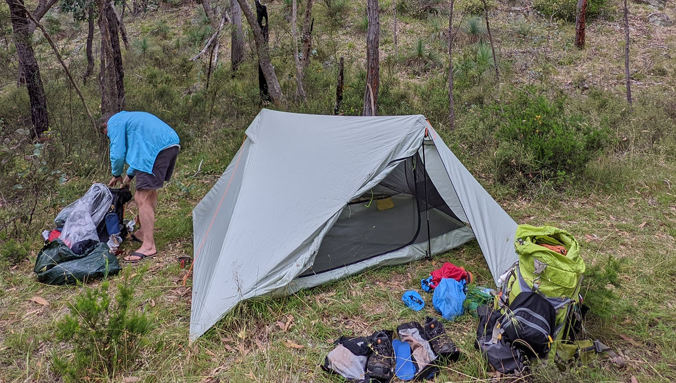
Tentage
Gordon has this lovely light two man tent. X-Mid 2P Tent designed by Dan Durston. It is light but needs hiking poles to keep it up and it does have a fairly big footprint but it works well in rain and moderate wind and has two generous vestibules and doors. So I took my Black Diamond Carbon Distance Z poles (more on them later) to use one for one side and Gordon carried a telescopic hiking pole for the other support. Worked a treat.
Things that go bang in the night
Sleeping mats are essential to keep you warm and comfortable, although Gordon found me once asleep in the tent with my Neo Air mattress newly inflated but not yet tucked under me. I was too tired to do it and had nodded off with it still sitting on top of me...
And they are not supposed to go bang, but that's exactly what Gordon's Thermarest Neo Air did, and not just once. On multiple occasions it let out a loud pop when yet another one of its internal baffles let loose and he ended up with a herniated foot-end on the thing with the bottom 6 baffles gone. Fortunately it didn't break any external seams and deflate so he was able to operate on it and tie off the foot end and leave it inflatable and useable. No doubt messages will be sent to Thermarest regarding warrantees...
There are lots of choices regarding mats, from lightweight cheap and reliable closed-cell foam to luxurious (but weighty and bulky) down-filled air mats. They vary in comfort, packed volume, cost and weight, naturally. I like the Neo Air by Thermarest (at least the ones that don't go bang) because they are very light, pack into a small-ish volume, work on snow as well as on tussocky grass and moderately rocky surfaces. However, it would be wise to think about what happens if they fail on a long trip. The closed cell ones are light and cheap, can't really 'fail' (other than being less comfortable) but they don't pack well because they are incompressible. BTW, if you use one and hang it naked on the outside of your pack, don't be surprised if it gets shredded at the edges by the bush. Put it in a tough bag to stop that.
Light 'em up
Torches. I got this a bit wrong, by being overly careful. I took two main torches, both rechargeable plus a spare battery for one of them. In the middle of the hike at a resupply spot, I ditched a torch and the spare battery into a drop-barrel to be retrieved later.
Gordon just took a tiny little Petzl head lamp that ran on lithium button cells. Mainly for reading. Probably weighed in at a poofteenth of nothing (10g maybe) whereas my collection would have come to twenty times that at least.
My reasoning was: What happens if we have to pathfind at night? What happens if a torch gets left on and flattens its battery? What if the electronics or batteries fail? All good questions and critical in certain circumstances, like alpine climbing or other situations where you can't really camp just anywhere and have to make it to the next campsite or perish. However, in summer when daylight is plentiful, where being caught out in the dark isn't going to kill you, perhaps a single torch (especially if reliable and rechargeable and you are carrying a charger) is sufficient.
Clothing maketh the man
Clothing was something I got wrong this time too. As well as mandatory hiking shorts and tee-shirt (or a quick drying long sleeved shirt like Gordon took would have been better) and down puffy jacket for night-times and secondary use as a pillow, I thought I'd need extra jacket and trousers as well as thermals to sleep in. I tossed in the down booties as well. They are light and on a really cold night very comfy. So far so reasonable. Then I wore a tracksuit for the drive up to the start and didn't want to leave it in Heather's car so I took that too. OK, so an unplanned change of warm clothes, so what? I'd appreciate it if it got a bit wettish. Except that I didn't realise it weighed 700g. I've been forced to become a gram-weeny in my dotage and that much extra would have horrified me. The very first night at Black Sallee lake seem to justify my choices as it was cold enough for the down booties and thermals under the summer sleeping bag. However, in the end, I only used them that once and at the halfway point I was happy to stuff about a kilo and a half of unnecessary clothes into a drop-barrel for later retrieval. (Actually, on a wet night a few days later after my raincoat had left me a bit dampish, I would have liked to have had that spare dry jacket...)
Forty days and forty nights, it rained
Speaking of raincoats, I got that wrong too. I have a range of coats, from a heavy-duty 3-layer Goretex monster good for blasting Antarctic blizzards down to ultralight things for running that might stop a shower, maybe. In the middle there was the choice between a long Torrent jacket from One Planet and a shorter Gore-Tex jacket from Kathmandu. (Model unknown but it had waterproof zips, pit zips, high pockets good when wearing a pack, nice hood etc and a 'Guaranteed to keep you dry' label. Clearly designed for this purpose, so I thought...) The Kathmandu one was a few hundred grams lighter so I chose to take that. It was a mistake. One morning of bashing through wet bush and hours upon hours of drizzle and the 'Guaranteed to keep you dry' Kathmandu jacket proved inadequate. Not cold and saturated or anything, but definitely on the dampish side. And before you start down on the 'but you sweated inside it' path, no, it was only a 16 degree Celsius day and I was not hot enough to sweat much. Mind you, if I had, the jacket fabric had well and truly 'wetted out' (the so-called durable water-proofing treatment had lasted all of 1/2 an hour) so the sweat would have had a hard time getting out. I'll keep it for day-trips or bike riding from now on, not serious stuff like this. I think the (obvious in retrospect) moral of the story is to take the raincoat you'd rather use in a bad situation and not the one you'd rather carry if everything goes perfectly.
About bush-bashing in the wet. I forebore to take waterproof trousers and so naturally my shorts got saturated when pushing through soggy bushes. No biggie, they dried out quickly, but I was envious of Gordon's rain 'kilt' and so on the second wet day I made a kilt for myself out of a big lightweight dry-bag. Worked OK-ish after a bit of fiddling with the depth of the splits required to let me lift my leg over a log or climb a steep bank but next time I'll bring a proper kilt or w'proof trews.
Sleepy bags
My choice of bag for this trip was easy. It was way too hot for the alpine bags but too cold for nothing so I went with my Western Mountaineering Summerlite. Rated down to 0 degrees C, but really only comfortable to about 5, it is light, packs down small and worked very well either as a true mummy bag or spread out as a quilt. There was one night where I needed to get my Kathmandu puffy down jacket on as well, but that was my fault for getting the bag damp. It was after that drizzly day going up and down from The Crinoline (Mt Ligar) and then walking for hours through the drizzle and my raincoat did a less than stellar job of keeping me dry. I thought I'd try to wear my damp clothes to sleep in and that they'd dry out from body heat (sounds silly, but this does work if you aren't too damp, say just a slightly damp tee-shirt maybe), but instead they just messed up the insulation of the sleeping bag. So I pulled the puffy down jacket out of its pillow-case and put that on after removing the damp jacket from the equation. All was toastie after that. In general, I'd suggest you avoid trying this method of drying clothes unless it is a warm night. Save them up for a sunny day instead. Mind you, sleeping bare-skinned on a Neo Air is not all that pleasant either, so maybe plan ahead and keep a light shirt dry for sleeping in. (This was after I'd left all my 'excess' clothing in the drop-barrel. Perhaps I should have kept just one spare tee-shirt. And a dry jacket. Sigh.)
Gordon uses a liner in his bag. Made from a thin, light, natural fabric that would reduce sweating and keep body oils away from the down bag. Good for you and good for the bag too. Maybe like this one: Premium Cotton Travel Liner - Sea to Summit
Lay yer head down
Pillows are important to me. If only I could just sleep on my back I wouldn't need one, but after an hour or so of that (unless really exhausted, when even a bare rock is comfortable) I have to roll onto a side. And then I need a pillow or my neck wakes up in agony. I've tried a few of the commercially available camp pillows, but found them variously too heavy, bulky or 'bouncy'. Sometimes I can get away with spare clothing stuffed into a dry-sack but the best is a puffy down jacket in a breathable 'fluffy' fabric like cotton or polar-fleece. So I take an old fleecy bag originally designed for a hot water bottle and stuff the puffy into that. Works a treat either on my side or on my back. You hardened travelers out there may well sneer in scorn, but I can't do it without something like this. Besides, the puffy is great in the evening before bed to keep me warm. And very light and packs well. Do have to keep it dry though.

Me poor toesies
Boots. Sigh, I always have this dilemma. Take an old pair (Merrel Moab Ventilators) that are well worn-in but maybe not as good as they might be, or go find a new pair that might be better/roomier/softer/more supportive (or which might turn out to be a nightmare)? I pondered on this until it was too late and I ran out of time to break a new pair in and so that made my decision for me. I did hedge my bets by including a pair of good, grippy running shoes in the drop-barrels in case the boots I started out with proved inadequate. The Moabs are a low cut hiking shoe, fairly light, don't even pretend to be waterproof (hence the Ventilator name though don't be fooled, I've found boots called 'breeze' and 'vents' that still have those damned Goretex bags inside them) and fit me about as well as any boot I've bought. Not perfectly because I have wide feet, but not bad, I thought. The drawback of them is that maybe they could have been a bit more cushioned or supportive and maybe I could have laced them up so they didn't slide around so much. (But then they would have put more side pressure on the little toes) In the end, my feet got pretty badly blistered, with pressure blisters under the ball of my foot, and rubbing blisters on little toes and heels and 'toe-jamming' blisters on the ends of all my toes. I even got blisters between my big and second toes where the ball blisters expanded. By midway I was in absolute agony with the first steps I took after resting for a while. The only fortunate thing was that after about a hundred meters or so of walking the pain from the pressures in the ball blisters settled down and I could walk without hobbling. Had to watch out about stepping on pointy rocks though. That really hurt. Blister-draining where I could and applying tape and Compeed hydrogel bandages helped though the Compeed didn't take well to getting wet and decided to stick to my socks. As I was wearing Injinji toe socks, that meant every toe was stuck inside its respective little pocket. And getting each bandaged toe back into its pocket when putting the socks on was entertaining too. Maybe the toesocks were a bad idea... Anyway, by the end of the trip my feet had hardened up and I was ready to go... Ooops, too late. Maybe next time I'll hit myself on the feet with a cricket bat a few thousand times to get them ready BEFORE the hike. Apparently running 30 km a week on offroad trails isn't enough preparation for hiking. Who knew? (I should have, this wasn't my first rodeo.)
How much of this pain was due to me being a tenderfoot? How much to the boots? How much was due to spending hours with soggy feet and boots caused by river crossings and being forced to wade up the Moroka R. because the paths on the banks were choked with blackberries or just non-existent? Should I have laboriously changed between boots and gaiters to sandals at every one of the hundreds of river crossings and then back again when I went into the snake-laden bush? We saw three red-bellied blacks but who knows how many we didn't see. Dunno. I do know that Gordon had fewer feet issues (but he is a tough old bird) and he did wear sandals a lot of the time.
I changed out of the Moabs into the runners at midway and that might have helped. Things got better, but was that the shoes or just my feet toughening up? I did get new toe-jamming blisters from that point on, and maybe the runners could be blamed for that... I did manage to stop the heel blisters developing further by trimming the insoles at the back and maybe reduced pressure on the little toes by cutting slits into the shoes' uppers to get a few more millimeters width. (Fortunately the mesh continued under the uppers so kept out rubbish) In conclusion, the only message I can give here about boots is the obvious one. Make sure they will work for you before you go. Don't rely on short trips with no pack to test them either. Just because they are good for a day hike doesn't mean a lot in this context.
Bigfoot
I complain about the shape of boots a lot, because I have a foot shape that is apparently uncommon. My big 3 toes are more or less the same length. This is called a 'Roman' shaped foot, I've learned from the internet and is less common (only about 10% of the population) than the Egyptian (longer big toe) and the Grecian (second toes longest). I also suffer from a form of metatarsalgia (Mortenson's Neuroma or similar) that was probably cause by wearing too narrow boots in the past and getting my metatarsals squished together. So these days I look for a boot or shoe with a wide toe box. You know, a boot that is shaped like a foot instead of some manufacturers' or designers' ideal of a foot.
Manufacturers are slowly beginning to take notice of the fact that not everyone has a narrow foot that comes to a point above the second toe. Some even make it a point of distinction that their boots/shoes are foot-shaped. Altra springs to mind for example. Hoka also. Even Salomon make some concessions here in some of their models and when I think of Salomon I think of long thin running shoes. (I've got a pair of their Supercross trail-runners and they are lovely and grippy but wearing them for more than a few hours hurts) Look for reviews of the model and brand you are considering. Many reviewers will complain about or praise the toe box in question (sometimes in contradiction of each other, which doesn't help). And naturally, try them on in a shop if you can. Stand on the ball of your foot and let your toes spread out. Take out the insole and put it on the ground and stand on it let your toes spread out and see if they overlap the insole at the sides. Check for ANY pressure on ANY toes and reject them if such is found. Even if they just feel a little snug. Make sure there is enough room at the front to avoid toes-jamming on the downhills. Make sure the lacing system holds your heels down and stops your foot sliding forward without having to be done up too tightly. NEVER believe the salesperson when they say 'Oh, the shoe will adapt to your foot as you wear them in'. This just doesn't happen. Of course if you are one of the lucky ones that actually has a narrow pointy foot that fits the 'standard' model, well, bully for you!
However, don't go overboard on roominess. If you get a shoe that is too big, your foot will slide around in it. This isn't a problem when walking on level ground, but when you hit the hilly or rocky bits it will cause you issues. Loss of stability for one and more pressure on the side of the big toe, I've found. Too much toe-room at the front will cause loss of grip at the toe when trying to rock-climb.
Waterproof boots or not?
Forget about supposedly 'breathable waterproof' shoes/boots, especially in summer. (Winter is a different equation) Even if they stop the water getting in from the sides (and 5 out of 5 pairs of Gore-Tex or similar boots I've bought in my naïve past failed to do so) they won't work worth a damn to keep your feet dry in real rain because water gets in through the idiot holes (you know, where the idiot inserts his feet) Even with gaiters and waterproof pants, which you'd think would prevent that, it's hard to keep the rain or the water from the bushes out. These 'waterproof' boots might work for shallow puddles or mud but, they will make your feet sweatier than a pair that are designed to be properly ventilated for hot humid Australian conditions, which dry out faster too. All this results in the skin on your feet staying nice and soft with moisture. Might be great for preventing cracked heels but I don't think it's great for preventing blisters.
Finding a non-waterproof pair will be difficult however. Most Australian shops appear at first glance to only carry the Gore-tex or NGX or other 'waterproof membrane' versions. However, I know that many of the big-name manufacturers do make 'ventilated' non-waterproof versions for hot conditions. Merrel Moab Ventilators, Salomon X Ultra 3 Mid Aero, Keen Targhee Vent, Oboz Sawtooth II are some possibilities. (In the end, after the hike, I got some Salamon X ULTRA 4 MID GTXs though I had to settle for the Gore-Tex version as the shop didn't carry the Aero that I wanted. Even though badged with a 'wide-fit' label I had to go to size US 11.5 to get the width I needed, way above what the Brannock Device would have recommended. Bonus is that these boots are really light! Downside is that yes, my feet get a bit sweaty.)
Ankle support
Another of the things manufacturers or vendors or other proponents might waffle on about when trying to get you to buy their boots is 'ankle support'. (Though I see it less and less in the manufacturers' blurbs. Perhaps they are paying attention, or somebody sued somebody) This can be as big a furphy as 'waterproof but breathable'. In my experience, mid or even high-top boots do protect you somewhat from grit and gravel and sharp sticks and rocks but rarely give you any more protection against turned/rolled ankles than low cut shoes. In fact sometimes they make it worse because they often have thicker outsoles and when you do turn your ankle it can turn thru a higher angle as a result. If you doubt me, try this experiment when trying on boots. Put on the boot in question, lace them up comfortably and tight enough as you would when hiking and deliberately turn your ankle out in an attempt to 'roll' it. (Do be careful, don't overdo it) Do you feel much resistance to the roll? Can you easily push it almost to the point of no return where you can tell it is going to go over and do you some harm? Every boot I've tested does this. None of them prevented it though some were better than others. I think that they never will unless they have some deliberately stiff element in the side of the boot to prevent rolling, maybe like a smoke-jumpers parachuting boot. Wouldn't wanna hike much in them though.
I bought a pair of OBOZ Men’s Bridger 10 inch B-DRY Insulated Boots once (actually three times but that's a different story about claims of waterproofness that all turned out to be false and resulted in warranty returns) on the premise of ankle support. They were good boots. Light, comfortable, somewhat water resistant (and we were in wet, boggy conditions for the best part of a morning on that hike), not too sweaty. I still rolled my ankle a coupla times, though not badly.
Look for boots with a good deep heel cup and a lacing system that holds your heel down, (this is also good for blister prevention) and offers good stability of the heel to reduce the chance of starting a roll in the first place. Overly wide outsoles at the heel or forefoot may or may not help. On flat ground they offer stability but that extra sticky-outy bit might actually catch on rocks on real terrain and make things worse. A wide toe-box will help I think, (and be good for bigfoots like me) because I think it enhances stability at the front of the foot (which is where a roll is often initiated from, rather than the heel, especially when running)
The best way to avoid a rolled ankle in my opinion is to be careful about where and how you place your feet and to carry not too heavy a pack so that you can recover when you do roll them without going over too far. I have developed a somewhat duck-walk style of foot placement, with the feet splayed outward slightly, especially when going downhill on rocky ground. But it doesn't come naturally and I have to consciously remind myself to do it.
Tussocky grass, or fields that are pock-marked from having cattle on them are the worst for rolled ankles, after downhill terrain with golf-balls on it. Mind you, asphalt with potholes in the dark isn't great either, or just plain not looking where you are going. The worst damage I ever caused myself in this regard was when wearing stiff mountaineering boots, carrying no pack, walking on a paved road but stepped into a pothole whilst daydreaming about something and not paying attention. Hurt like hell and took weeks to recover from.
A strapping young lad
I have had success using sports tape to strap my ankles, especially when trail running. Done carefully it can provide a measure of protection against rolls. (Done badly it can lead to blisters on your legs where bits of tape don't overlap and cause shear stress on the skin!) However, once it gets wet, the tape loosens and becomes useless as it relies on the tape sticking vertically to the skin on the outside of the ankle and lower leg to provide tension for support, so on this trip it wouldn't have lasted more than a day. Could be done, just need to carry lots of tape.
Alternative footwear choices
Maybe I should have worn thongs (flipflops, not the other sort) or sandals all the way. Don't laugh, if it weren't for the snakes, I'm sure Gordon would have. But I hate it when little rocks get under my feet or sand gets under the straps. Besides they slip around too much for me when wet and as for rock-climbing, forget it!
I did briefly consider Vibram Fivefingers (you know the ones with individual toe pockets) but in the end I chickened out. Not enough between me and the hard, sharp rocks and pointy snake fangs. I once spoke to a guy who was wearing them whilst backpacking in Larapinta (rocky desert country in Central Australia) and he said "It only took a week to get used to the pain". Maybe that's why I chickened out. In retrospect, it still took me a week to get used to the pain in the conventional boots I wore on that hike. They went into the bin the minute it was over. Hmm. Still, snakes.
Socks
Another miscalculation on my part led me to take Injinji toe-socks as my main socks. I like them as they help prevent blisters cause by toes rubbing together. What I didn't take into account is how hard they'd be to put on if toes had to be bandaged, especially when the bandages would rather stick to the socks than to my toes. In retrospect I'd mix it up a bit more, with some more conventional socks and fewer toe-socks. Do take spare socks though, and maybe a pair just to sleep in. Wash and dry them when possible on the hike.
BTW, I am coming to the conclusion that too tight socks might also aggravate forefoot squeezing and/or end-of-toe issues. It does seem odd that such a little pressure might cause concerns but I find that when my feet are hurting, taking off tight socks gives immediate relief so there must be something to it. Just yesterday I went for a run and found my right middle toe was having pains. I took off the outer sock (I was wearing normal running socks over very light inner socks, almost stockings) and immediately the issue went way. So just the thickness of a running sock was causing a problem. Admittedly, this was only a few days after the McMillans hike so my feet are pretty sensitive right now, but even so. So do take the usual advice about wearing your hike socks when you go to try on hike boots seriously, and do try to do that at the end of the day when, supposedly your feet are most swollen. Maybe do it immediately after a 220 km hike when, my feet at least, are really swollen!
Gaiters
Apart from wanting to keep the snakes at bay, blackberries and random sharp sticks pose a threat to my legs so I took a pair of bush gaiters. Once upon a time they were 'waterproof' snow gaiters but the semi-permeable membrane is now extremely permeable and that's fine. Didn't want waterproof anyway, just get even more sweaty. Gordon had customised canvas 'snake gaiters' he'd modified (he modifies everything, the clever fellow!) to make them even longer and more breathable. Both types went up to just below the knees, fastened with Velcro and press studs, had an elasticated tightening cord and worked fine though mine were a bit sweaty and we didn't get to test them on snakes. Pity that.
Do tuck that elastic cord in though. Once I forgot and left it loose and it got caught in a bush until it let go with a twang and came back and hit me painfully in the back of the knee. Thought I'd been snake-bit there for a second!
Another thing I must warn you against, though I'm sure you don't need it. Don't wear your gaiters when fording a raging current. The water catches them, opens the Velcro and turns them into instant sea anchors and your feet wanna go downstream.
Gi'e it some stick mon!
Walking poles. Necessary? No, except for holding up the tent and possibly a stick would have done though I wouldn't have liked to risk holing the tent on any jagged edges on the thing. On the other hand, I doubt I'd have made it without my Black Diamond Distance Carbon Z Trekking Poles especially going up those interminable gung-ho tracks and fording those creeks full of slippery algae-covered rocks and really especially when my poor feet had been worn down to blistered nubbins, so I recommend them. These are really light and strong, but you have to buy them in your size as they are not adjustable. I love my stix. (Hmm, there's a pun in there about crossing rivers and Styx, isn't there?)
Do be careful about jamming them between rocks though. Being carbon-fiber, they are really good in compression but too much bending moment and they would give way with a sad and expensive little 'crackle'...
Infernal devices

I do like a nice GPS receiver with displayable map. I also despise having to recharge them all the time. I spend a bit of time now and then working on a design for an e-paper based device with a 7" screen. I want a highly selectable level of detail using editable Open Street Maps (JSON versions) and have it programmed in Circuit Python (or even better Python). It needs a low-power GPS receiver module that has non-volatile memory and a low-power 'sleep' mode and selectable intervals all on a low-power host with uA 'deep sleep' so that I can tweak the software to perform as I want it to. Meanwhile, until that pipe-dream comes to fruition, I have a bevvy of off-the-shelf models to choose from. I knew I'd take my Fenix 5x watch because it is light, has maps, would have a GPX track downloaded to it to follow, would warn me (somewhat) when I got off-track, is rugged, waterproof and easily looked at etc. Supposed to be able to do normal Navstar-only GPS tracking for 12 hours with second-by-second sampling rate and even longer at 25 hours using a slow-sampling Ultratrac mode but the positioning accuracy that Ultratrac gives is rubbish and I don't use it. Besides, measurements I've made convinced me it doesn't actually make much difference to battery life. But I only got about 6 or 7 hours at the most. This disappointed me as previous trials did get about 12 hours. Maybe the battery is losing potency... (Hmm, the Fenix 7 has just been released... Much longer battery life...) (After burning out the USB port on the Fenix 5 on this trip I got a Fenix 7x Solar. It has great battery life, 80 hours using GPS at 1 s interval or 20 days if using the Expedition mode and gps at 15 min intervals...)
I also wanted to take my Garmin InReach Explorer+ satellite communications messenger, which also has a GPS map mode. This is my goto device in case of disaster and has an SOS button that can call in the cavalry. It also lets me stay in touch with home via text when I am not in cellphone network covered areas, which was most of the time. It even allows me to share my trip via a website, on the fly!
The Pixel 5 smartphone I usually carry was also a must, for photos if nothing else, but it also can run the Garmin Explore App that does a decent job of letting me plan and carry out a route, even update the routes on the Fenix if I can stand the multiple tries and uncertain success involved in synching the two. It does have its other quirks too (like hiding the positions of huts until you zoom right into almost the highest res, which means that you have to know here the hut is in order to find it... Why, why, why? Is it the TopoActive map, or the fault of the app developers? Scathing queries have been sent!) I was worried about battery life on the Pixel. However with Extreme Battery Saver on and Airplane mode on and WIFI and Bluetooth off it gave VERY good results. Only went down about 5% in 8 hours. Being left on whilst I hiked meant I didn't have to wait minutes for startup and satellite acquisition. Used the power button (there's a setting for that) to open the photo app and it was ready in seconds instead of tens of seconds. This is important because if there is a long delay before the camera is ready the subject (unless it was scenery) usually scurried off into the undergrowth (including Gordon who was patiently indulgent most of the time, nonetheless I didn't want to stretch his good will).
I also carried a GPS equipped EPIRB but that doesn't need recharging and you can't get the positioning info out of it. That's just for the cavalry.
Gordon carried a phone with the OsmAnd app and OSM maps, and that gave us one more way to not get lost. Or to get us unlost when we did.
All these GPS things, in conjunction with the printed track notes and maps in a waterproof bag that Gordon carried were useful to help us in navigation and wayfinding. The only time we got a little bit lost was completely our fault for daydreaming. Diversity was key here. Where one device, say the Explore App on the phone, was lacking in detail, say the name of a track or the position of a hut (Grrr) then one of the watch or InReach or OsmAnd or printed notes probably had the missing info. Proved very useful to have so many alternatives. Of course you can go overboard. Perhaps you think that the InReach satellite messenger with SOS button AND the EPIRB weren't BOTH needed? Let me ask you that question again after you are faced with the situation of having been bitten by a snake whose venom will kill you in a few hours if you aren't very careful about not moving. And you are in a remote ravine with limited access to satellites for the satellite messenger and the cellphone naturally can't see a network because you are too far from towers. In that case, I want all the resources possible to reach out for help. InReach appears to be very good, but having the EPIRB backup at the cost of 250 grams was worth it to me. At least I left my Garmin Dakota 20 handheld behind, lovely little thing that it is, it's made redundant by the Fenix watch.


Wer'e da Hekawe: Navigation and pathfinding
According to the writings of the legendary Korean military scholar General Soon Sing Song, she says, "Navigation is the art of knowing where you are, knowing where your destination is and then the path needed, according to the roads, the terrain, the weather and the deployment of the enemy, of getting from one to the other. Pathfinding, however, is the art of knowing which rock to stand on next". In our case the enemy was the blackberries and trackless bush. The weather didn't really play a part in navigation but in cases of flooding or high winds or lightning, it would have been best to avoid low and high grounds. Terrain is always important. Best to avoid steep bits if possible. Mostly we chose to use tracks and roads as advised by Chapman's notes, but sometimes we chose to use alternatives that would bypass choked gullies, ridges made difficult by regrowth, or just plain boring bits. 'Interesting' bits were treated with caution too...
A map and compass can go a long way to help with the navigation, i.e. the strategy, and certainly having a compass bearing helps to guide the pathfinding, i.e. the tactics needed to carry out the navigation plan.
All of this does require you to know where you started from and where you actually are at a given time. Skilled users of map and compass can, with keen observation of the landscape (and sometimes signposts) get a long way in working their position out. However, a GPS receiver with a map (or the ability to give map coordinates that can be referred to a paper map) is a great boon to the modern traveler in the bush. Used properly, the GPS can tell you where you are with great accuracy and guide you in both the navigation and pathfinding. We relied on the maps and notes for working out how to get from A to B and the GPS receivers to make sure we stayed (when sensible) on our planned path and to anticipate turnoffs. We also used our discretion to re-plan the path on the fly if it proved to be infeasible due to lost path, blackberries or thick scrub. Mostly we were following an obvious path like a road or a bush track or a river and that made pathfinding pretty easy, but now and then the path was inscrutable and we just had to pursue a general heading or follow terrain features like ridges or rivers. It wasn't hard but it did take some thought. It really helps too if all parties in the hike participate in pathfinding especially when the lead hiker is focused on the path immediately ahead and the second or later hiker can look around a bit more. Also it is easy to miss a turn in a vague bush path so when the lead hiker finds that the path has disappeared, the people behind might actually have a better view of where it has gone, or at least of a clear spot in the bush that would make progress easier than that horrible tangle that the path has apparently led us to. Gordon was great at spotting turnoffs and track-marking triangles and bits of pink tape that I completely missed when out in front. We did not rely on the triangles however. They were too sparse and too easy to miss, but they were a welcome confirmation when encountered. As for the pink, green (!) or blue tape we came across, all that they really meant is: 'Someone else has been here and they might have been just as lost as you are.' Welcome them but don't trust them too much.
Now you might take exception to the number of GPS devices (4 including the phones), maps (5 including printed ones) and compasses (2, one of which actually failed on us!) that we carried on this trip (detailed in the Infernal devices section) but to underline the importance of redundancy, I just finished watching a YouTube video about an experienced solo hiker in Tasmania who had to call in the rescue chopper because he lost his only navigation device, his phone. It was in thick bush, foggy and he couldn't see the sun well enough to know North from anywhere. No compass, no paper maps, no backup GPS and his only recourse was his EPIRB. (He went back and did that track again, armed with satellite messenger and GPS and compass and printed map as well as his phone the second time)
Used without proper knowledge and caution however, the GPS device and its maps and marked courses can also mislead you with great accuracy too. Some problems we encountered were:
GPS device wouldn't lock onto satellites and give a position, for a while. This usually occurs when in a ravine or when it is misty or rainy. Just be patient.
GPS device (actually the electronic compass within it, not the GPS receiver) pointed in the wrong direction. Especially in smartphones, the electronic compass used to work out which direction it is pointing when not moving needs to be calibrated, which involves waving the device around in a funny figure of 8. Unfortunately if you aren't aware of the possibility of it being needed, the compass can quite easily mislead you. You also get a bearing from the GPS signal and that requires you to be moving so if you see a conflict between the direction you are facing when still and the same direction when you are moving, your electronic compass needs a calibration.
Gordon's magnetic compass permanently decided to point South instead of North. Still wondering about that! Is it even possible? Apparently. See Reverse Polarity in Compasses - Glenmore Lodge
Fenix watch didn't give a strong enough indication of 'off course' and we walked past a turnoff whilst slaying blackberries. It just vibrates 'brrr' once, gives a screen indication and that's it. Doesn't repeat and the 'brrr' is easily missed if your arm is busy working out a cavalry-sabre backhanded slash. People have whinged on the Garmin forum for a long time about being able to customise the indication to get a longer or repeated buzz but so far to no avail. Simply put, pay bloody attention to your pathfinding!
Interpretation of the track notes. Although good, Chapman's notes sometimes needed a bit of cogitation. e.g. instructions like: "Follow the vehicle track.... meet Champion Spur no 5 marked on some maps as CS3. Turn right and follow the vehicle track..." do require some thought. Is the vehicle track we are meant to follow the original one or the new one? Did give us pause, but wasn't hard to get right, especially by referring to the printed maps and various marked courses on various GPS devices.
GPS device said we were off course and urged us to 'go into the woods' but they were gnarly and tangled and monsters lurked therein and we could see a better, clearer way to go, even if there was no beaten path. This happened on the Long Hill course to The Crinoline when the clear path we were following entered a clearing and no obvious exit path could be seen. It was made worse by various bits of pink tape indicating that yes, someone had been here before, but still no real path was obvious. However it was clear to Gordon at least that we should stay out near the 'rim' where it was clearer of scrub and bordered by rocks shielding us from a steep drop off rather than follow the marked course religiously. This worked, so if possible to do so without messing up the navigation, your pathfinding strategy should be: 'Don't go into the deep dark woods'. In this case it was clear from the maps that following the rim would get us to where we needed to go, and Gordon had a memory from long ago about all this so we went with his plan and hit the campsite perfectly with minimum bushbashing. Sometimes the marked course is just wrong, whether because it was entered into the GPS device improperly or too coarsely or because the maps were wrong or because some numpty had decided to make a new path and not enough people had used it because it was silly.
Not on this trip, but a sour memory from the first GPS device I ever carried (and never again) was that I could NOT find the menu item to navigate back along the route we'd recorded on the way out. This was in bitter cold in the snow with a rapidly draining battery and I wasted (what felt like) half an hour scrolling through menus and settings. Turns out that that setting was only available if you landed on the navigation actions page from a particular starting point, otherwise it was invisible. Aaaaargh! Nested menus with disappearing options are the WORST idea we software people have ever come up with! Take home message is 'Practice with the GPS before trusting your life to it'. (We made it out alive, BTW)
Maps on some GPS devices not detailed enough. Yeah, like the TopoActive Australia map on my phone used by the Garmin Explore app. Very uncluttered by silly irrelevant details like medium sized creeks, minor track names, huts etc. Aargh! I was standing right next to Lankey Plains hut and it didn't show on the map at a reasonable level of zoom. When I zoomed right into where I knew it was, suddenly it popped up as a tiny weeny icon and text. How ridiculous! I had to know exactly where it was in order to find it and look at the size of the text and icon compared to the dashed line of the track.

Charge!
All these devices meant I'd need a recharger. About 10,000 mAh ought to do it, though your needs might vary. More charge means heavier charger. For me, 10 Ah was enough to charge everything a couple of times and the Fenix watch every day. I included a spare recharger in the drop-barrel. A cheapie from Jaycar and a slightly more expensive ruggedised one from Decathalon did the job. Plus all the various different cables. Speaking of cables, the Fenix has a 'special' cable to charge it and do you think the bloody thing would stay connected? No, I had to clean the contacts, make sure the springs on each little 'pogo-stick' pin weren't jammed up and then jiggle it around until the watch went 'brrrr' unless the recharger had given up and turned itself off by then, and then very carefully put it down without bumping the cable and disconnecting it. All in the confines of a two man tent. Aaaargh! More scathing messages to manufacturers were drafted whilst I held the cable in place. (I am convinced that all this jiggery-pokery with the charging cable is what burned out the USB port on the watch...)
Gordon's needs were more modest and he put a 7,000 mAh charger in the drop-barrel to recharge his phone and Kindle e-reader at halfway.
Chapman's track notes
McMillan's Walking Track is an excellent resource giving good detailed track notes. One thing we noticed though was that we usually took a bit longer to complete a section that the notes suggested. Maybe we took longer breaks, or I was just plain slow. Also, anytime it mentioned 'track may become vague or choked with blackberries' we knew it was going to be a monster. 'Steep short ascent' should be read as 'brutal' and 'challenging' means exactly what it says. 'Interesting' needed to be treated with caution.
Ooooh, me back
What backpack to take? Again, purchases in the past gave me some options. I needed probably more than 40 and less than 80 liters capacity and wanted lightweight, but comfort is definitely an issue. A good supportive belt and straps are essential and don't forget about ease of access. Belt pockets, waterbottle pockets, little clips on the shoulder straps for GPS device and camera bag are all important. You don't want to have to stop and take off the pack just to access water or find out where the heck you are or to take a photo.
In the end I settled on my ExPed Thunder 70 which weighs in at 1.6 Kg. I could have taken the even lighter ExPed Lightning 60 but I don't like its rolltop (I like a conventional lid pocket) or the very light (900g) Impact Leisure 40L but I didn't trust that 40L would be enough or maybe the Kathmandu Varoo 75L but it is a sturdy pack that weighs in a full kg heavier than the ExPed Thunder. Better support though but I wouldn't really need that for a mere 17 kg load (Hah!).
The ExPed Thunder is supposed to be weatherproof. Nope, it's not. Just as well I've learned a thing or two in the decades and put everything in drybags or I would have had soggy clothes, sleeping bag, food etc.
Backpack envy
Gordon's Z-Pack fared better in the waterproof stakes and is certainly even lighter than the ExPed Thunder. Not sure what model he has but I like the look of their Arc Air Robic 60L even if it doesn't have a conventional pocketed lid. Only 700-ish grams! A full 1 kilo off my already lightweight ExPed! Wow. You can't pay for that... Actually you have to pay for that. The less you buy the more it costs, when talking about hiking gear.
Next time I will consider my 900g Impact Leisure 40L pack. It would have been big enough, in retrospect and limited capacity might have dissuaded me from taking too much clothing... And despite its low weight I bought it at a bargain for $80 from Anaconda a long time ago but have never used it for much. Never quite trusted it. Seemed too good to be true. Unknown minor brand and worried that it might be a horror to carry or break a zip or burst a seam in the middle of the hike. Only way to find out is to use the dang thing, so next weekender, it's the one. (Actually since then I did try it and wouldn't use it again for more than a daytrip. The back length (i.e. the height at which the belt sits) is too short for me and is not adjustable. This is sometimes one of the things they leave out to save weight and cost...)
Take a load off
How much weight to carry in total? Food plus gear plus clothing plus water?
I aimed for 17Kg with water and managed to do it, but in the end that was too much. Ditching stuff at midway helped make the second week much more enjoyable. In future I'm going to aim for 12 Kg for a week. Of course a lot depends on your particular physical state. I used to carry 25 Kg (though admittedly, I never found that to be much fun and I was always rolling an ankle badly at least once per trip) Better, lighter (more expensive) gear makes it possible to reduce the load, but really, as evidenced by my ruminations above and below, it comes down to what you choose to take (or maybe more importantly, choose to leave behind)
Don't stint on nourishing food. If it's too heavy, eat faster! But don't be stupid about the weight of packaging. We came across some of someone's lost gear on the path and it contained a glass bottle of rock salt. Not a small bottle either. What on earth were they thinking? And it had no calories! Madness.
Fire!
What about cooking? Basically heating water was all we needed and not for warmth or anything. Choices for us were gas or shellite and although better than gas in the cold and snow, shellite wasn't really necessary in this case. Also slightly heavier and more fiddly. Also riskier (says he who once almost burnt down New Federation hut due to a cracked fuel line). Gordon has a lovely gas stove like this one from FireMaple, Blade 2 Titanium Backpacking Stove, though his is not made from Titanium. It has the gas connected to the burner via a hose, which makes it lower, more stable and easier to keep out of the wind, unlike my Pocket Rocket that sits up on the gas cannister. We took both, for redundancy and because I like to boil up water for coffee in the morning whilst the other burner is busy making porridge.
It's a gas, man
I found a great source of gas at K-Mart where they sell 230g cannisters for $4 which sell for $12 dollars in dedicated camping stores (cough, ripoff) These are Korean made and worked fine. We worked out that 3 of the 230g cans would do us for the 12 days, with plenty of reserve, so we carried one each and had one in the drop-barrel. Previous measurements showed that 1x230g can would do the 2 of us for 5 days, based on about 1.5 liters of boiled water per person per day. I.e. say four 250ml cups of coffee/soup/tea, 1/2 cup for porridge and one cup for freeze-dry meal per person, plus maybe a 1/2 cup per person for dessert. Be aware that the 230g is the NETT weight, i.e. just the weight of the gas. The can weighs about 110g empty. So at about 15g of fuel to boil one liter, you get about 15 boiled liters of water from a cannister. Half or a third of that if it is constantly windy or in the cold. Half that again if you are going to be melting snow for water. Altitude throws a spanner in the works too. Water boils sooner but doesn't get as hot so food can take longer to cook. Do note that unless it is for reasons of killing pathogens, you may not need to actually boil the water. i.e. for coffee or soup.
I think that we pretty much emptied one can and the other two were probably left about half full each at the end of the trip, so with care (and me drinking less coffee) we could have done it with 2. However, we were not going to give up the hot soup at the end of the day, no way! And I get grumpy if I miss my coffee in the morning...
Put that fire out!
Keep water handy to put out any grassfires your stove might cause. Cook on something less flammable than old dry grass. (I used my soggy gaiters spread out on more than one occasion) Cooking in the rain is challenging and on a couple of nights we cooked under the tent fly in a vestibule. This is where the shellite stoves would have been at a disadvantage as they can easily flare when first lit but the gas is better behaved. Ensure good ventilation in this case and be vigilant and wary of things like an un-secured tent flap dropping onto the stove. (Almost happened to me when a wet fly that had been folded back and was held just by water tension suddenly decided to flop down. Sorry Gordon...) Also be careful of spilling the hot water on yourself when cooking, especially in cramped conditions or on uneven ground or when passing around the hot soup. In case that happens, pour lots of cold water on the burn as soon as possible. Soak it in the creek for 10 minutes if possible. Don't do what I have seen some YouTube videoers do and cook inside the tent itself. It's too easy to tip it over and burn a hole in your floor. Or unthinkingly put down the hot pot and burn a hole in the floor. Be careful of carbon-dioxide and monoxide build up too. Make sure of your ventilation. This is very important in snow caves, but also in tents.
Campfires? Despise them. Take too much work when I'd rather be sleeping. Only purpose would be to dry stuff out and that means after or during when it's raining and then it is even harder to start the damn things. Considered it a bit but never used one. Saw plenty of car-campers that appeared to believe that you absolutely had to have a roaring great fire going in the middle of a stinking hot day in order to sit around drinking beer and try to keep cool. And who forgot to put them out properly when they left, in at least one case. And which required chain-sawing the bush around the campsite in order to feed aforementioned conflagrations. Did I say I despised campfires? Maybe I should have been more targeted with my contempt.
Slash and burn
I wondered if I should take a machete? Just for slashing blackleberries, not cutting down forests for firewood. The Gerber Gator or Bolo from Anaconda looked good, though way too heavy at 700g to 1Kg. Maybe an Imacasa 18 Inch Pata de Cuche (300 g!) In the end I decided not too. Would have been useful though. A Jedi light-sabre even more so...
Water
Water is obviously important. You need a lot of it every day. Like 2 or 3 liters per person and even more when it is hot. There is no easy way you can carry enough to meet your needs for multiple days, so you have to resupply frequently. Take some water-purifying tablets or a UV-steriliser, or a good filter (maybe a pump one. I found the squeeze one I tried was much too slow) to prevent infection from dodgy water. Get your water from running water well upstream of any campers. And boil, filter, UV-sterilise or add appropriate purifying potions to it if in an area with livestock or ferals like deer, brumbies or pigs. Treat still water (i.e. not running) with even more caution.
One of my most prized bits of camping gear is a simple waterbag I made about 40 years ago. Recipe goes like this:
Buy a cheap cardboard cask of wine with a bladder in it. A nice Moscato perhaps, if you like it sweet. 3 or 4 liters ought to do. One with a valve that pops off. This might be hard to determine at first and some experimentation might be called for
Drink wine. Check on valve popping off ability. Repeat until successful
When hangover subsides and you are feeling better, take bladder out of cardboard box and rinse it out
Get an appropriate sized canvas gear bag, with a drawstring, for the bladder to go into, cut a small hole down the bottom for the valve to poke out of
Tie a string to the valve cap so that you don't drop it in the creek when filling the bladder. Make sure the hole you put in it for the string doesn't compromise water-tightness, otherwise go back to step one
Put a handle made from a bit of plastic tubing on the rope of the bag because thin rope will hurt your hand when carrying the full bag back to camp from hundreds of meters away
Toilet paper and rubbish
Do remember to take toilet paper and put some spare in your drop-barrel. Also take some Imodium or similar diarrhea pills, just in case.
Take a lightweight trowel to dig a pit to bury your crap, well away from water. It might be difficult in stony soil but do your best, and then pile rocks on it. When we did the AAWT, Gordon and I came across where some car-campers had stayed and it was disgusting with a toilet-paper littered gully just behind it. Despite the fact that their 4x4 was carrying a big shovel and a mattock, they had not even tried to bury their crap at all. Yuk. Be better than that.
Plan to carry out your rubbish, or leave it at the drop-barrel at midway for later retrieval, so minimise it beforehand by taking things out of cardboard boxes and so-on and not carrying cans or bottles. If you can carry it in, you can damn-well carry it out. Don't plan to bury it. It only gets dug up by critters.
Snakes and spiders and leeches, oh my
Plan for some wildlife. Take and know how to use a snake bandage or two and have a means to call for help if the worst happens. Don't rely on your phone. We saw a total of four deadly red-bellied black snakes, two large but inoffensive goannas, one big water dragon, a huge skink (bluetongue? Probably but he didn't oblige by poking his tongue out at us) and numerous smaller lizards. No crocodiles. One great big spider I managed to coax out of her hole in the ground and thousands of small spiders that insisted on building webs across the tracks at just about face-level. Ptah!

These spiders are one of the reasons Gordon liked it when I went first down the bush tracks, though he'd often run into my back when I stopped suddenly, waving my sticks madly in front of my face to clear away some overlarge arachnid that was aimed at a face to face meeting.
When we went down the track near Lazarini Spur we found great water, but it came at the cost of going into leech-city. We pulled quite a number of them off ourselves afterwards. Also on the Black River section they were lurking in the damp undergrowth and this time one got me. No photos because by the time I dealt with it after finding where it had battened onto me and gorged, there was nothing left but a burnt, bloody smear on the rocks. Take that you parasitic hermaphroditic annelid you. It had its posthumous revenge though, as I write this a week later, I still have an unhealed itchy red welt where it bit me.
Deer were apparently plentiful. We heard bugling in the night and saw lots of footprints. No deer themselves though (except for bits of a dead one I found just upstream after getting water. We didn't use that water and thoroughly pilled the water we did get from even further upstream that night).

This next beastie obviously hadn't heard the oft repeated advice about snakes 'hearing us and crawling away'. I think that is a rubbish statement anyway, I've seen numerous snakes like this that weren't in the least bit inclined to slither off. Maybe if they are out in the open they stay put as a defensive measure and maybe it's only the snakes in the grass that slither off. (No, not all of those either, as evidenced by an incident we had on the AAWT a coupla years ago) Either way, keep your eyes open for them and wear protective shoes/boots and gaiters when walking in the grass and bushes. Don't poke them with a hiking pole or stick as they will turn back towards you and strike. Stamping at a distance sometimes encourages them to move off. Just go around them in the tail-end direction, if possible.

Going forth. Enough Prep, let's do it!
Hike prep finished with a drive from my home in Lysterfield in Melbourne, down to Gordon's place in Warragul, to do a drive up past Licola to place resupply barrels at about half way. Food, water, gas, rechargers, fresh undies, drop-day celebratory items like orange juice and pineapple pieces and chunky soup-inna-can, that sort of thing. Duly waypointed on various GPS devices we camouflaged the drop-barrels in garbage bags and hid them as best we could and then abandoned them to the weather for the next week. I left wondering how the cheese would fare in the heat... (went fine, just a tiny spot of mold where it had been cut. Next time get a smaller block and don't open it)
A few days later along with my wife Jennifer who was going to drive my car home, I drove down to Gordon's place again. Then along with his wife Heather he and I drove up to Cobungra, near Omeo, to start the hike. Clearly an important part of the undertaking was keeping in sweet with our spouses who did the car shuffling for us. Thanks, Ladies.
Whoa oh Black Sallee, wham da lam
Day 1 Cobungra to Black Sallee lake
It was a short, pleasant walk from the Cobungra turn off from the Omeo to Hotham road to the first campsite, along Victoria River track. The lake was dark and gently misted when we got there, as the air had turned cold. We saw what we initially took for brumbies on the other side of the water but it turned out they were riding-horses and we saw and heard people once in a while.

Getting water was a bit dicey from the lake as the edges was soft and it looked a little manky anyway. So I found the inlet stream which was flowing weakly and followed it upwards a bit to get to somewhere that looked better. I had to throw away the first water I got because I also found a dead deer leg just upstream from it but then even further upstream I found better flowing water anyway. I tried the Lifestraw filter bottle I'd brought to clean it up a bit but it was way too slow. I got about 2 liters through it before my hands started cramping from squeezing it and deciding that this was silly and just doped the water up on iodine and/or chlorine pills. The filter bottle got put away and abandoned in a drop-barrel at half way. Doubt I'll ever use it again except maybe as a personal drink-bottle (which is probably what it was designed for, to be fair).
Road, him go up, him go down again
Day 2 Black Sallee - Lankey Plains Hut via King Spur Track
I've decided that a lot of the roads in this part of the bush must have been built by a primitive race that hadn't invented contouring. Either that or some guy in a bulldozer had been instructed to minimize distance, tree-felling and rock cutting. (We called him George but learned later from cold-water guy that his actual name was Aubrey) Many of the roads we encountered took the shortest path from A to B and if that resulted in a 25% or more grade, well too bad. Greater than 25% means it rises more than 1 m up for every 4m forward which doesn't sound like much, but you try walking up it for a few kilometers in the heat! It's not as steep as a staircase but it feels like one without treads! A bit of rain then turns it into a rockface in some cases. If anyone knows why it was done this way, we'd love to know. Can't have been for logging trucks, too steep. Fire access maybe? Kept open now for tourism?
In this case, on the track we came down on day 2 after a nice hike from Black Sallee, they had closed the road reportedly because it was too steep and people kept dying on it when their cars rolled. It had revegetated somewhat but it was a doozy and I was too busy trying to stay upright to take a photo of it. To keep people in cars off it they felled logs and dug berms across it and generally turned it into something even 4x4 drivers would hesitate at and say, 'Whoa, now, lets have a think about this!', which takes some doing. Wasn't fun to walk down either. Here's what Parks had to say about it. (Found here: Mayford Spur Track Via Dargo High Plains | 4x4Earth)
'The track from the Dargo River up to the Dinner Plain Track has now been shut for many decades and will not be re-opened. During its time open it posed many challenges for managers and due to grade was a safety risk. We utilised the road as a fire containment line during the 2003 fires and even then, it was risky for staff and contractors on machines.'
You can get an idea what it was like from pictures in this link Mayford - Mayfors Spur Track CLOSED (4x4earth.com)
After a rest at the bottom of the closed Mayford Spur Track we eschewed the usual path going on to Mayford Flats and then up Treasure Spur as we were worried that the spur would be choked with regrowth. We chose to go up Kings Spur Track instead which was obviously open because the 4x4s were roaring down from it. A few river crossings and a long hike up the road got us to Long Spur Track and then a flattish path alongside Devil's Hollow. We were greeted by a number of the many car-campers ensconced there, one guy waving beer in the air. Tempting, but no. Wanted to finish the day. This eventually led us to Lankey Plains Hut, which was in the middle of a muddy moat dug by thoughtless drivers and currently occupied, so we pushed past it and up onto a tussocky field for the night. After arguing with the ants we finally got the tent up and I tried some astrophotography on my Pixel 5 after dinner to see if I could get the dead trees starkly outlined against the Milky Way. Useless camera app interface defeated me, not for the last time.

Timber!
Day 3, from Lankey Plains Hut to 25 Mile creek via White Timber track
Down Dargo High Plains road a little and then off into tussocky plains to find a boundary fence which we followed until it got us to White Timber Spur North track. The tussocks were a complete pain and made for slow going. The road and fence are such that we actually went some way along the fence more than we needed to before doing a hairpin turn on the road and coming back. We were looking for the turnoff, but it was bit too low down for us to see.
Then down that track to Ritchie Road and over it to White Timber Spur South track. It was a hot day and my feet were killing me already. Really glad to see the end of the road but then we had to descend a really steep, but thankfully zig-zagging single-track through the bush, down to 25 Mile Creek. Even if some of the zags were pretty precipitous, it would have been a nice section except it was at the dirty end of the day. Then across the creek to a tiny campsite just barely big enough for our tent. Baths in the creek followed to wash the trail dust away. No nudie photos. I do have some sense of good taste.
Here be dragons
This big water dragon I didn't even have to sneak up on. After making soup I sat down exhausted on a nice rock to rest my feet and there he was only a coupla meters away. Even stayed still long enough for me to get the camera out and snap a few shots. That's star quality that is.

Blackberries, benching and Bulltown spur
Day 4 From 25 mile creek to Bulltown Spur
Parts of the track on the next days first section had nice stonework holding it up and making for a good benched track. We did have to carve our way up out of the campsite through blackberry bushes to get going, but I managed to find a jewel in the brambles, a small raspberry with some tasty fruit on it. Yum. After all the bush-bashing to get to it that morning, this clear part of the track was delightful walking. This photo shows where it had probably been recently restored.

Walk a crooked mile

On to Thirty Mile Creek and then to Crooked River, hiking on reasonably good tracks high above the river. No real crossings until we got to Bulltown Spur that evening. When we got to where we were planning to stay after fording the crick, there were a few blokes sitting at their cars and vans, playing gin rummy or something and I bellied up to them and asked brusquely, "Are you blokes going to be partying noisily all night, or what?" They answered "No, certainly not" or similar, with affronted mien, to which I responded, "Bugger that then, I'm not staying here". After ensuing hilarity (wry grins, 'cos they were laconic Aussie blokes) one of them pointed out a nice grassy campsite a few hundred meters down the track. It was one of the better spots we camped at. Nice starscape too.
Astrophotography
I love the astrophotography feature on my Pixel 5 phone's camera app. Well, let me rephrase that. I love the results (when I can get them) and I hate the user interface. Here's how I would describe the process: Open the camera app and select 'night vision'. Keep the camera very still in a dark place and magically it will decide to go into astro mode, which takes multiple images and 'stacks' them and does other automatic editing tweaks. Dare to move it whilst trying to press the 'take the bloody picture' button and it'll drop out of astro mode back to single-shot and admonish you for not keeping still. Now imagine doing all that whilst the camera is pointing straight up. (That's where the stars are, right?) So, the screen with the button and the icon indicating astro mode is pointing straight down, which means that to see it you have to have a tallish tripod (nope, left it behind, too heavy) or you've managed to balance the expensive phone/camera overhanging enough from a rock or log with enough room to get your head under it to see what's going on. Or you manage to use the timer feature and hope that it goes into astro mode and doesn't just take a single night-vision shot. All the while you are standing on your head in the dark and the mossies are sucking you dry and you are freezing to death. (Slight hyperbole there, it was actually fairly warm. The mossies were real though...) Oh, and if you do manage to be lucky enough to start the photo in astro mode, it does it all silently so you don't really know it has worked until you wait for three minutes and then pick it up and have a look. (I ruined a couple of tries by picking it up early) Of course, it does tell you what's going on, but it's all on the screen you really can't see because the camera is on its back on a log! I spent a good part of my walking time during that hike composing a scathing letter to the idiotic developers of that app asking why they couldn't just have a fixed astro mode instead of one that turns itself on and off! Also designing a makeshift 'tripod'. After I got home, I discovered that I could have pressed the volume button to take the photo (there's a setting in the camera app...) That would have helped a bit. Anyway, here's my 'tripod' design. (yeah, yeah, only got two legs... You know what I mean, stop being pedantic. That's my job.)

I have since learned that the best way to use the Astrophotography mode on the Pixel if you don't have a tripod is to face the camera down on the grass, pointing at the ground so you can see the screen. In the dark and not being jostled, it goes into asto mode and then you can press the 'go' button and flip the camera the right way up again and point it at the stars. Seems to work well. Maybe even use the shutter delay feature though it doesn't seem to care.

This photo was taken at our campsite near the Bulltown Spur on Crooked River on the end of day 4. I managed to 'paint' the trees with my torch just at the right time to get them lit up in the photo. (This was a matter of luck. It doesn't spend all its time acquiring so a brief flash might get missed) There is some blurring on the leaves, but who cares. It's a marvelously starlit image from such relatively unsuitable camera hardware, (small lens, small sensor, low exposure time) without needing a tracking mount, thanks to the 'stacking' methodology and other tweaks. (Google 'astrophotography on Pixel' to find out more.) Pity about the useless user interface, but now that I know better, I'll use my 'facedown' trick or I'll take a superlight tripod next time, or a phone holder I can clamp to a hiking pole or a tree or something. Maybe one with a bluetooth shutter trigger (K Mart have one for $25 with said accessory. I got one a few weeks later and it does the job. Light, has a good smartphone adapter that works with my thickly armored Pixel and the bluetooth trigger just works. Nice.)
Why did the hiker cross the river?
Day 5 Bulltown spur to Eaglevale
In the section down the crooked river on day 5 there are 23 fords to cross. It was a hot day and the rush of the cool but not cold water wasn't too challenging most of the time. It was fun. Did have to watch out for 4x4s coming thundering over the banks and running us over though. Gordon was halfway across when one pair of cars came thru, but they slowed down and didn't swamp him. At another crossing I had to hold onto a lively young pitbull puppy that had come waggling across the track to greet us just as a convoy came recklessly splashing across the ford. Doggie wanted to run back to his boss, right under the wheels of the cruisers, didn't he? Barely managed to hold him and didn't get bitten even once.
I could usually tell how high the water was by sending Gordon first and checking the pitch of his voice. When it reached soprano I knew it was too deep.

A plum spot
Talbotville made a nice lunch spot on day 5 after all the river crossings in the morning. There was a big open parkland with lots of people having a good time. We found a delightfully shady place in an old orchard that had ripe plums to eat but unfortunately unripe pears and figs for us to only contemplate. The plums were delicious. I've often come across fruit trees at old settlements and this was the first time they've been ripe. If only Bloody Baron Von Mueller (Introduced plants | Ergo (slv.vic.gov.au)) had thought to send out packets of apple seeds instead of blackberries to be sown in the wild, things might have been much better.
Oh, the horror!
After our restful lunch, we metaphorically girded our loins (how exactly do you do that?) and then we had to toddle along Brewery Creek Road for a bit and then divert off onto a short section of the Bicentennial Trail that coincides with McMillans track to bash through insane blackberry and bush regrowth down to the Wongungarra river to get from Talbotville to Station Track. Yuk!
Then there came the horror of Station Track, which was another of those 'straight up to the top' roads, but with added spice of a very hot day and very little shade. We must have looked in dire straits as we struggled up it from tree shadow to shadow. A convoy of 4x4s came down and the lead one stopped to offer us some water. When finally we made it up and recovered, it was down from the Cynthia Ridge track almost to the Wonnangatta River, along a private fence through horrible long grass to the suspension bridge and then into a nice open flat, accompanied by 'doof doof' music from the car-campers. This is when the 'cold-water guy' that inspired me to perpetrate this blog came over and had a chat.
I tried again to do some astrophotography that night but the useless interface defeated me. Would only have been boring stars without any landscape anyway. Pah!

Moroka River, hunting thundereggs
Day 6 found us going up the Moroka Junction Track (road) until it abruptly stopped being a road and turned into a walking track. Rested there for lunch and were amused by the 4x4 drivers that roared in, had a look and then roared out again.

After lunch we tried to walk alongside the Moroka river but failed to have a lot of fun. The track was indistinct and there was plenty of bush to push through. We found it a lot easier to go down to the river and either wade up it or better, walk on the pebble shingles. This is where I first realised that gaiters and rushing currents were not a good combo.


Rollin' stones
I knew from notations on the maps that thundereggs (geodes) could be found around here and I kept my eyes open as we waded up river, possibly accounting for how slowly we made progress. Didn't find any conventional candidates, but did find some unusual opaque, white, egg-shaped pebbles, possibly river-tumbled amorphous quartz or quartzite, that had what looked like a web of harder, probably quartz veins embedded in them and slightly raised on the surface in a polygonal pattern.

Using 'lens' image search on the phone, the best hits I got were for Septarian nodules. My guess is that they were formed by deposits of harder minerals in cracks in a slightly softer matrix. Then tumbled in rivers for millions of years.
Shelob and her spawn (Caution, upcoming arachnid images)
At the campsite (confluence of Carey's creek and Moroka River) for day 6 I sat down with a tree at my back for a much needed coffee and happened to glance down and find a silken tube about 4 cm across sticking up dangerously near my groinal area. Rather than mindlessly panic (which I really should have but I needed that coffee. It'd been a hard day), I finished my coffee and then after wisely retreating a bit I tickled the edge of the nest with a stalk of grass to see who was home. The big (maybe female wolf spider) critter that came thundering out covered in spiderlings I called Shelob and after teasing her out of her nest I relented and left her alone. Poor thing, all those kids constantly on her back and they with a wandering father, she didn't need people knocking on the front door all the time.

Here's a video of Shelob attacking my grass. I'd put my hand down there for scale, but no, I'm not going to do that. Don't play it if spiders scare you. Oh, too late... BTW, if this video won't play and appears all grey, try refreshing the page. I've found that works sometimes. Also, the video is part real-time, part slow-mo, just for kicks. You can tell which is which when the birdsong goes all 'bwahh, bwah...'
Drop-barrel day!

Day 7 was drop-barrel day and we really had to earn it. Started well with a wander up the Moroka River but then we decided to bypass Playboy Creek and the dubious 'interesting' bit up a possibly poorly defined D4 track to climb up the Moroka River Track to meet Doolans Plain track and then a bit back down Moroka Road to Volkswagen instead. It's named after a long removed junk vehicle. That climb was a nightmare for my poor feet, but we got it done and then we could celebrate with some orange juice and some lovely chunky soup in addition to the usual freeze-dried Lamb Roast with Vegetables (or whatever) followed by juicy pineapple pieces. And I changed my boots. I love drop-barrel day!

Day 8 Volkswagen to Shaws creek
From Volkswagen, we marched up through Arbuckle Junction the next day and then over Mt Arbuckle, had lunch at Kelly's hut (unattractive on the inside so we sat on a nearby log) and this morning was some of the nicest walking we did. (Maybe drop-day celebratory feast helped) Gordon reminded me that we'd been here before when we went skiing on Mt Reynard a few years back. I remembered the log.
Then on towards Shaw's creek. We had a chat on the road with another 4x4 driver who expressed some interest in the McMillan track, despite his little girl urging him to 'let's go Daddy, stop talking to those weird men'. Then on to the campsite where we found a few car-campers sitting around and one of them trying to catch fish. We camped a bit away from them on a tussocky hill and hoped that they didn't decide to shoot at the deer that was bugling nearby in the middle of the night.
Petticoat junction
Day 9, Shaws creek to Long hill
We decided to 'skirt' the part of the McMillans track that went via Mt Tamboritha and Breakfast Creek in favor of going around via Long Hill and Mt Ligar (The Crinoline) because Gordon didn't like the Breakfast Creek route (long and booring) last time he did them and besides this gave us a chance to summit on Ligar and take in the views. (Hah!)
On the way we stopped for lunch at the Rock Shelter. Nice spot with good shade on a hot day. Actually it was almost cold, but that was a welcome relief.


We were lucky to get this vista of Mt Ligar (The Crinoline) on day 8 from Long Hill because the next day when we climbed it, it was all misty and we could see nothing. D'you reckon it looks like a lady's petticoat? Well, actually, see some of the images in Death by Crinoline? - Molly Brown House Museum.
When I went back to the area a couple of weeks later to retrieve the drop-barrels, I climbed the Crinoline from the other side (starting at Breakfast ck. I will write it up separately so if you are interested in what the view should have looked like, look for it here: https://terrycornall.wixsite.com/website/post/petticoats-in-a-twist-on-the-crinoline)
After rock shelter we had that issue with the path going invisible and eventually we just followed the rim around to the campsite. Getting water wasn't fun because although there was a blazed tree showing where to go to get it, the path faded to nothing after a few hundred meters and I just had to keep heading east, pushing through the bush until I got wet feet to find it. Nice water though. Cool on the toesies.
Misty Mountains

Day 10 and from the camp on Long hill we went up Mt Ligar in the mist, after a bit of a bash through wet bush. Had the morning bath at the same time. Getting to the summit wasn't hard, even though we couldn't see much. Once we got across the narrow ridge that joins Long Hill to Ligar, the bands of rocks that give it the Crinoline monicker make nice terraces, with a bit of a scramble to get up between them in a number of places. The difficult bit was working out what path to take to go to get from band of rock to band of rock. Gordon did a great job of pathfinding and we didn't waste a lot of time searching for these transitions. In places the path goes up slopes of gravelly rock that slips under your feet, and some short climbs are required. It's not terribly exposed (or shouldn't be if you are taking a good path), there are good steps and handholds and occasionally making use of some handy vegetable handholds helped.
There's a nice copse of trees on the summit of Ligar that would make a reasonable campsite, if the winds weren't too strong and from there following a fairly well formed path along the ridge down the South West side gets you to a junction with McMillan's track again. This path is nicely zig-zagged and not crazy steep anywhere. Another little rock down-climb is needed but it's easy. Do be careful though. I make light of the difficulty but in a number of places on Ligar a slip would result in a painful and possibly dangerous tumble. Just take it thoughtfully as you go.
Then down to the Macalister River and after a pause under the porch of a farmer's caravan/hunting-hut/retreat overlooking the river, we went up the long dull, soggy Glencairn road to Middle Ridge Road and then to Rumpfffffs, Flat. (Or however you stop spelling it) Couple of 4x4 drivers asked us if we were Ok on the way past but didn't offer us a lift. We would probably have said 'no thanks' anyway. At least the first time.
A maze of twisty little passages, all alike
Rumpff Flat to Lazarini Spur via Mt Shillinglaw, day 11.
Next morning we endured a long steep climb out of Rumpff Flat along McMillan Spur Track to get to the Jamieson-Licola road and then we were almost back on familiar territory for me as the AAWT intersects McMillans Track near here. I still have post-traumatic flashbacks about hauling our drop-day barrels and water over the Rumpff Saddle on that particular trip. (Bad planning to leave drop-barrels too far from camp, and the Barkly River Jeep Track there is a perfect example of why you don't make roads so steep that they erode away to rockfaces. Besides, it turns out that there is a perfectly good drivable Barkly River Logging Road that could have gotten us all the way to the camp to leave barrels there, if only we had known. Anyway, on this trip we didn't go so far up the Jamesion-Licola Road, turning off to go to Mt Shillinglaw and then camp at Lazarini Spur instead.)
For some reason I don't have photos of them, but on this day we traversed bush tracks like the imaginatively named No 18 Track that is maintained apparently by driving down it in a golf-buggy sized vehicle with whirling blades all around it. They were like green tunnels cut through the living bush and apart from some fallen logs and sapling stumps to liven things up they were easy walking. We did get so engrossed in whacking blackberries on one section that we missed a turn-off but that only cost us a few hundred meters and some embarrassment.

I did get yet another fine photo of my favorite stinkhorn, Aseroe rubra somewhere in that section too.

We got water before the camp at Lazarini Spur by going down a small track that went past a couple of caravans, apparently lodgings for weed-spraying contractors. I hope that they were there to get the damn blackberries. There was good water there, but also a LOT of leeches and we were lucky to get away without getting sucked dry. That evening when choosing a tent site, we were repelled from the best choice by an ants' nest. Gordon found an alternative saying, 'this looks ok, a bit soggy, probably why there aren't any ants here'. It rained that night and guess what happened... Yup, we discovered whether the tent could float. Fortunately it could.
Welcome to Tombstone, population you
Day 12
From Lazarini Spur we went down to Black River and up again the next day. I vaguely remember some nasty 'short steep' bits and a bit of scrambling but don't recall it being too horrible. I must have blanked it out, because Gordon reminded me again about the short, overgrown but steep bit out of the Black River. Look at these two consecutive track elevation profiles. What do you think? Nasty? Well, almost every day looked a bit like this, so no wonder it has all blurred in my memory. Toss in blackberries and regrowth and it becomes the stuff of PTSD.


Oh, and there were leeches waiting for us at the bottom, around Black River. I unknowingly picked one up inside my gaiters despite vigilance and didn't find it until later after we'd climbed all the way out. It didn't survive the experience.
After the brutal scramble out of Black river and dealing with that impertinent bloodsucking hitch-hiker, we were sitting under some Cherry Ballart (Exocarpos cupressiformis - Wikipedia) trees, all of which were unfortunately bare of fruit. Except for one that improbably had just two of its tiny little red inside-out fruity goodies that caught my eye. They were tasty, but that was all there was.
On another cheerful note, I took this photo on day 12 somewhere between Lazarini Spur and Standers Ck where all these tombstones were poking up out of the ground. Spooky.

Although they look it, these bits of rounded sticky-uppy rock are not man-made, but rather something like a metamorphic mica-rich phyllite that has been tilted up and weathered. There was a whole graveyard of them. (I could make a pun about a pile of old schist but that wouldn't be gneiss...)

Then we came across this old ore crusher just before crossing the freezing Stander's creek at the end of the day's walking.

However this was one campsite distinctly over-endowed with verticality and somewhat lacking in horizontality. This was night 12 at Stander's Creek (Hah, standing room only creek...) and the only spot that looked at all possible for the tent was a narrow terrace, a relic of goldmining activity. We looked up and down the track for alternatives, even going to the point of walking further up the steep track to see if it topped out onto something usable. Nope. So back we went to this site and got paleolithic on its grass. I.e. we dug it up and extended it using flat pieces of rock as shovels, some flakes of slate that happened to be handy. After half an hour's grunt work we had a platform that might do but it meant one side door was unusable and that the tent roof on that side was a bit wonky, but we decided to leave it at that. It was at least level on the floor, kinda. (Not really, I had to wodge clothes and stuff under my sleeping mat to stop myself pushing Gordon out his side of the tent) It rained that night and a big pool of water gathered in the tent fly. We were lucky though that it didn't rain too much and we didn't get inundated.


Oh, you take the high road
Day 13 Last day!
The last leg of our trip on day 13 was up the monstrous slope of the Abbot Creek track out of Stander creek and then along a flattish bit until we got to Johnson's Hill.

Then along the Johnson Hill track and then the Goulburn river into Woods Point. At one place we chose to take the road above the creek. Looking down it to the valley flats showed another road that crossed the river a few times. It looked quite attractive and we wondered if it might have been better.

At this point at an old reconstructed miner's hut just before Comet Flats outside of Woods Point we read Chapman's notes and got quite confused by them. Eventually we worked out what he was trying to say though some of his comments didn't make sense to us at the time. (Looking back at the notes now they seem perfectly straightforward. We must have been brain-fogged by the thought of almost being finished...) Nonetheless we took his advice about keeping to the right on a road climbing above the river. It merely meant that we could follow a road above the Goulburn river and keep our feet dry. Going the low route meant a few more creek crossings, which wouldn't have been terrible.
I'm not a celebrity, but get me out of here anyway
Once the hike was done we needed a retrieval. Gordon's son James did us the favor of coming up to Woods Point to get us, and then regaled us with stories of being a ski bum in Japan. So jealous.
And that's it, apart from going back to retrieve the drop-barrels one day real soon before everything in them goes moldy. I'll wait for some good weather though, and summit Ligar again and see if I can get some good photos this time.
Like I said above, I'm glad I did it, had fun on some bits, hated others and wouldn't do it again in its entirety for a great big clock. Life's too short. Now, if you'll excuse me, I have a nice little 28 km trail run down on the Mornington Peninsula to prepare for. Bye for now. Terry.


